Eugene, OR
Blog Post Number 2
 |
| This image helps visualize how the air masses flow over the United States with the states outlined clearly. Image Source: http://teachers.oregon.k12.wi.us/mahr/assignments/airmases_fronts_storms.pdf |
 |
| This diagram depicts perfectly how the Aleutian Low affects the Pacific Northwest of the United States. Image Source: http://bioregionalexplorations.wordpress.com/page/3/ |
 | |||
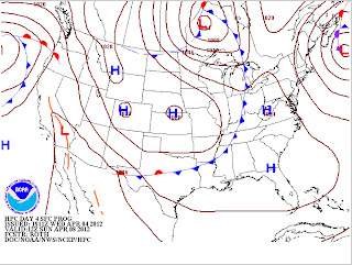
| Click to View Animation This provides an example of a warm front entering the Oregon coast in the Eugene area, then turning to an Occluded front. Image Source: http://www.hpc.ncep.noaa.gov/basicwx/day0-7loop.html |
 |
| If the animation above changed this is the next image of the occluded front. Image Source: http://www.hpc.ncep.noaa.gov/basicwx/day0-7loop.html |


No comments:
Post a Comment